CAPTURE facilitates rapid assessment of threats posed to groundwater supply wells while enabling hydrogeological delimitation of wellhead protection areas.
CAPTURE implements a sophisticated probabilistic capture zone analysis using groundwater travel time equations originally derived by Bear and Jacobs (1965) under the assumptions of zero recharge and uniform aquifer properties. However, because aquifer properties and local groundwater conditions are never exactly known, CAPTURE computes travel times to production wells using many different stochastic realizations of:
- hydraulic conductivity,
- aquifer thickness,
- porosity,
- groundwater gradient, and
- groundwater gradient direction.
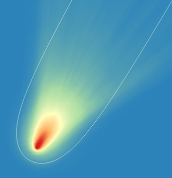
The user identifies a production well, specifies the range and probability distribution of each of the above parameters, and then selects a target travel time. CAPTURE then records the probability that the groundwater travel time is less than the target value across all nodes of a user-defined grid. These georeferenced capture probabilities are readily imported into a GIS for visualization over maps and images.
Optionally, CAPTURE allows for the construction of histograms showing point-to-well travel times at user-defined observation points.
In its current configuration, CAPTURE provides a first-level assessment based on analytical solutions formulated in probabilistic terms. The approach has been tested on Italian water supply wells and has been approved by water management services and regional authorities.
A more advanced (yet still automated) capture probability assessment—based on MODFLOW 6 numerical simulation—is planned for the near future. This second-level assessment will extend CAPTURE’s applicability to the delimitation of spring protection areas, and will support spatially varying recharge, heterogeneous aquifer properties, and interactions with boundary conditions.
CAPTURE can be run in either deterministic mode or stochastic mode.
When run in deterministic mode, CAPTURE obtains a single set of aquifer characteristics from the DET_PARAMETERS block of its input file. It then writes five output files. These are as follows:
- A SURFER BLN file defining the infinite-time capture zone boundary;
- A SURFER grid file that allows contouring of travel times to the extraction well from points within the capture zone;
- A MIF/MID file pair recording travel times to the extraction well; this can be imported into a GIS;
- A CSV file recording travel times; this can also be imported into a GIS.
The grid over which travel times are evaluated is specified in the GRID section of the CAPTURE input file. Points in this grid for which travel times are not computed (as they do not lie within the capture zone) are awarded a travel time value of 1.701410E+38 in the SURFER grid file; this is SURFER’s blanking value. They are awarded a value of ‑100.0 in the MIF/MID file pair that are written by CAPTURE. Non-captured points are omitted from the CAPTURE-produced CSV file.
If run in stochastic mode, CAPTURE generates random realizations of the following aquifer properties. Travel times are calculated for all of these realizations.
- hydraulic conductivity;
- porosity;
- hydraulic gradient;
- bearing of hydraulic gradient;
- aquifer thickness.
Hydraulic conductivity and porosity are assumed to be log-normally distributed while hydraulic gradient, the bearing of hydraulic gradient, and aquifer thickness are assumed to be uniformly distributed between user-supplied lower and upper bounds.
If run in stochastic mode, CAPTURE writes the following files:
- A SURFER grid file recording the probability that the travel time is less than a user-supplied threshold;
- A MIF/MID file pair recording this same information;
- A CSV file recording this same information; optionally points can be omitted from this file if the probability is below a user-specified level;
- A CSV file in which travel times are recorded for all realizations at a set of user-supplied observation points; randomly-realized values of aquifer characteristics are also recorded in this file.
CAPTURE was developed by Watermark Numerical Computing, with support from Kataclima, Italy.
UNDER CONSTRUCTION